Envis Centre, Ministry of Environment & Forest, Govt. of India
Printed Date: Sunday, October 26, 2025
About Kerala
Kerala is situated in the lush southwestern corner of the Indian subcontinent. Kerala boasts a rich tapestry of art, culture, and historical trade connections with distant lands. Renowned for its stellar achievements in education, healthcare, gender equality, social justice, and law enforcement, this state proudly holds the mantle of the highest literacy rate in India and the lowest infant mortality rate in the nation. Nestled between the majestic Arabian Sea to the west and the verdant Western Ghats (Sahyadris) to the east, Kerala spans an area of 38,863 square kilometers. It stands as one of the states that constitute linguistic-cultural area known as South India, flanked by its neighbours Tamil Nadu and Karnataka. Noteworthy is Mayyazhi (Mahe), an enclave of Pondicherry (Puducherry) nestled within Kerala's embrace, while the Lakshadweep Islands, though a Union Territory, share deep cultural ties with Kerala.
In the annals of history, Kerala once reigned as a princely state, a relic of pre-independence India. On July 1, 1949, the princely states of Travancore and Cochin merged to birth the Travancore-Cochin State. Subsequently, with the inclusion of the Malabar district and Kasaragod Taluk of South Canara district (formerly part of the Madras state), the entity transformed into the Kerala we know today, officially established on November 1, 1956.
The Land
The tropical climate and the rich monsoons offer beautiful landscapes, the presence of abundant water bodies, long beaches and the 44 rivers add to the charm. The geographic location for Kerala, India, is approximately 8° 17’ 30” N to 12° 47’ 40” N latitude and 74° 27’ 47” E to 77° 37’ 12” E longitude. The state is divided into 14 districts, each with its own distinct identity and importance.
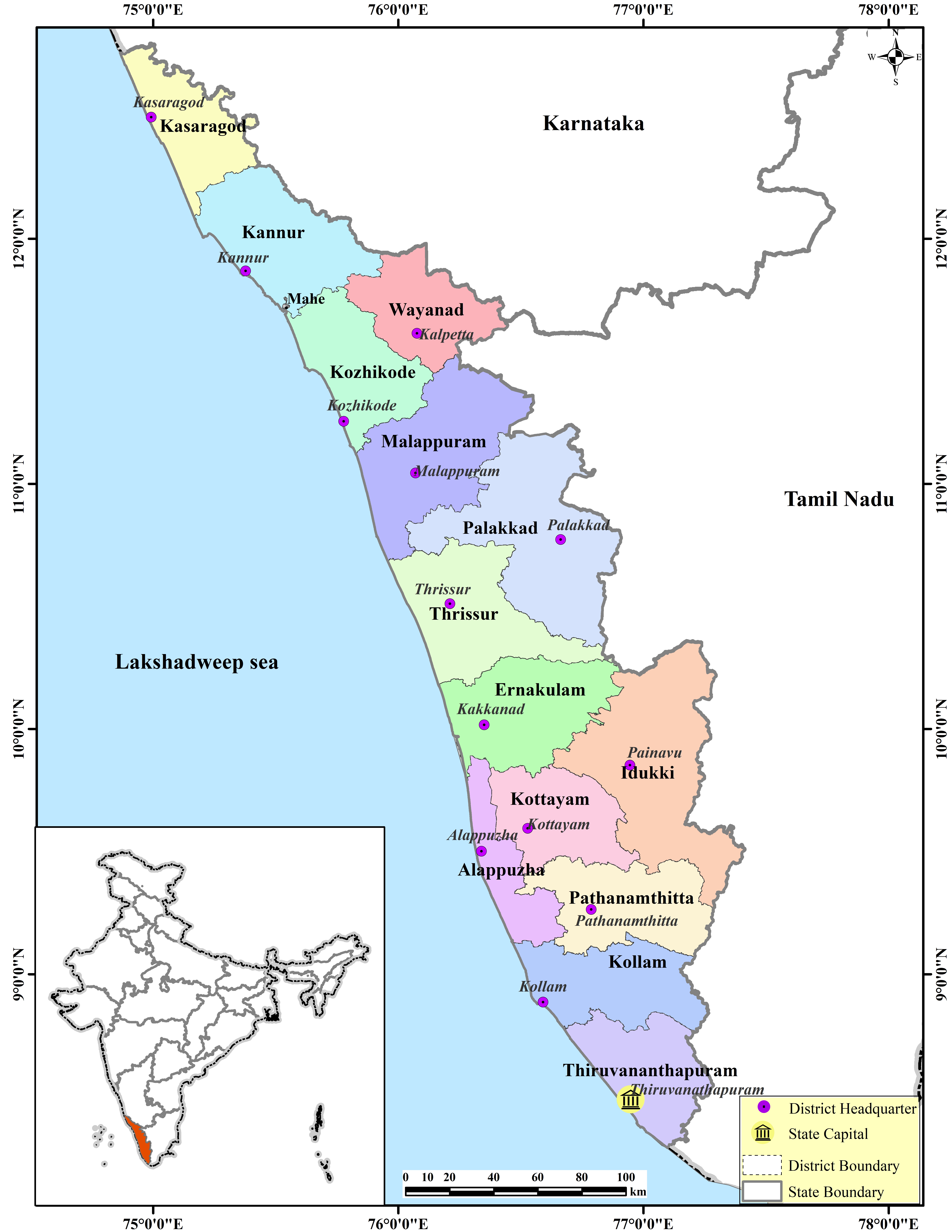
Geographically Kerala is divided in east-west direction into three parts- Highland, Mid plains and coastal areas. The area in and around the Western Ghats or Sahyadri are mostly hilly and thick evergreen rainforests. The major rivers of Kerala originate from these highlands. Silent Valley in Palakkad district is one of the bio-diversity hotspots in the world. The highest peak in Kerala is Anamudi (2695 m). On the West, the Coastal belt lies parallel to the Western Ghats. In between, the highland and coastal plain lies the mid-lands. It is generally a combination of hills and valleys. The 41 rivers flowing to the Lakshadweep Sea and the lakes in the west, the three east flowing rivers, the lakes and backwaters make Kerala a water-rich landmass.
Climate
Kerala, situated approximately 80 kilometers from the equator, encounters a tropical climate. The region experiences three distinct seasons: the South-West monsoon from June to September (known as Edavappathy), the North-East monsoon from October to December (referred to as Thula Varsham), and the summer season spanning March to May. Unlike many other parts of India, Kerala's winter season from December to February is not prominently pronounced. The climate is distinguished by gentle breezes and swift monsoon rains.