Environment
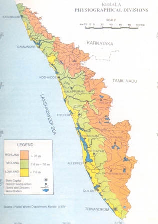
Physiography
Kerala State is situated between 8 o 8' and 18 o 48' North latitude and 74 o 4' to 77 o 50' East longitude, along the windward side of the Western Ghats of Indian Peninsula . The State is located in the tropical region of Indian Peninsula and extends to an area of about 38863 km2, which accounts for about 1. 2 per cent of the total geographical area of the country. The State is bordered by Tamil Nadu State on its South and part of the East, Karnataka State on the North and part of the East, the Lakshadweep Sea on the West and the Indian Ocean along the South. The State has a total coastline of about 560 km and from sea level it rises to about 2694 m above msl.
Because of the location of the State along the windward side of the Western Ghats , it receives an average yearly rainfall of about 3000 mm, and the precipitations in the South-West and North-East Monsoon period, may go even up to 5000 mm, especially in the higher altitudes of Wayanad and Idukki plateaus. The average temperature of the State at 1ow and medium elevations ranging between 0-700 m is about 23oC. Between 700 - 1400 m above msl, the temperature fluctuates between 16 and 23oC and in the high altitude areas along the crests of the Western Ghats , it is about 15oC during the coldest months. Above 1400 m elevation, the average temperature is even less, ranging from 13.5 to 16oC, and it is in this zone that the shola forests, with similarities in species representation with the temperate Himalayan forests, are distributed in the State.
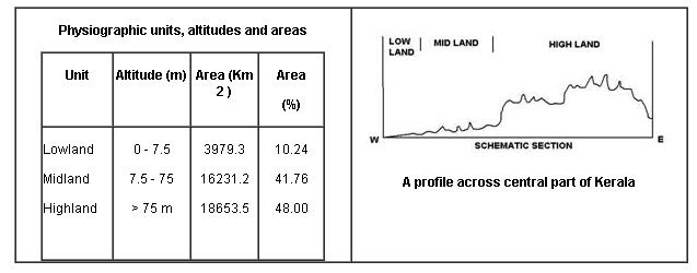
Physiographically, the terrain has three natural regions namely, lowlands, midland, highlands. A physiographic classification, identified mainly in terms of broad geomorphic surfaces and altitudinal characteristics, is also used in the parlance of geographers (CESS, 1984). It has five physiographic zones, namely, high ranges with elevation above 600 m, foothill zone between 300 to 600 m, upland regions between 100 - 300 m, midland between 20 - 100 m and coastal areas and low land below an altitude of 20 m.
Kerala has 44 perennial rivers, of which three are East flowing and the remaining 41 are emptied into the Lakshadweep Sea , along the western side of the State . Rivers are generally swift flowing having very steep gradients in their higher reaches. Absence of delta formation is characteristic of Kerala rivers. The general drainage pattern of these rivers is dendritic, although at places trellis, sub-parallel and radial occur. The segments of river courses are nearly straight, indicating structural control, coinciding with the prominent lineament directions (NW-SE and NE-SW). As per national norm (Rao, 1979), there are no major rivers in Kerala. The four medium rivers, namely Chaliyar, Bharathapuzha, Periyar and Pamba have a total drainage area of only 8250 km2 with length 169 km, 209 km, 244 km and 176 km respectively. The length of rest of the rivers varies from 16 km to 130 km, with an average length of 62 km and total drainage area of 19,485 km2 . The river flow is modulated by about 30 reservoirs, mostly located in highlands (KSLUB, 2002; CWRDM, 1995). There are two fresh water lakes in the State namely the Pookot and Sasthamkottah. The State is also having a total of 46.13 km2 of estuaries and backwaters. The important backwaters are Vembanad and Ashtamudi lakes.
Ten broad groups of soils based on morphological features and physico-chemical properties have been identified in Kerala (Anon, 1978). They are red soil, laterite soil, coastal alluvial soil, riverine alluvial soil, grayish Onattukara soil, brown hydromorphic soil, hydromorphic saline soil, acid saline soil, black soil and forest soil.
The major forest types represented in the State (Champion and Seth, 1968) include the dry deciduous, moist deciduous, semievergreen, evergreen and shola forests.Almost 78 percent of the total land area of the State is under agriculture and dwelling, and the remaining 22 percent of the land is under forests and forest plantations. Quite obviously, the pristine status of nature is better protected only in a limited area, and that too in the higher altitudes, whereas, most of the remaining area of the State is subjected to degradation and transformations of various types.
Reference:
State of Environment Report Kerala